
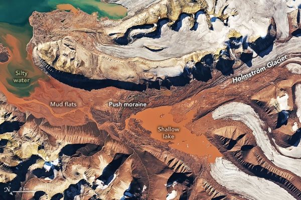
On the island of Spitsbergen, glaciers grind up sandstone, leaving an abundance of sediment that stains the meltwater.
Svalbard, an archipelago between mainland Norway and the North Pole, is known as something of a mecca for geologists. It is one of the few places in the world that has easily accessible rocks from nearly every geological time period. There is little soil or vegetation to cover up the remarkable geologic diversity. And despite the Arctic location, ocean currents moderate the weather enough to keep much of the land clear of snow in the summer.
Among the more striking geologic attractions, at least when viewed from above, are glaciers on the archipelago’s northwestern island of Spitsbergen. The ice there seems to “bleed” meltwater that is an intense shade of red. The Operational Land Imager (OLI) on Landsat 8 acquired this natural-color image of red water pooling in a shallow meltwater lake near the terminus of Holmström glacier. The image was captured on August 23, 2020, shortly after an unusual heatwave brought record-breaking temperatures to Svalbard. The image below shows a wider view. Note that the image has been rotated to combat relief inversion, an optical illusion that can make valleys look like mountains.
Continue reading at NASA Earth Observatory
Image via NASA Earth Observatory


