
It took fifteen years of imaging and nearly three years of stitching the pieces together to create the largest image ever made, the 8-trillion-pixel mosaic of Mars’ surface.
It took fifteen years of imaging and nearly three years of stitching the pieces together to create the largest image ever made, the 8-trillion-pixel mosaic of Mars’ surface. Now, the first study to utilize the image in its entirety provides unprecedented insight into the ancient river systems that once covered the expansive plains in the planet’s southern hemisphere. These three billion-year-old sedimentary rocks, like those in Earth’s geologic record, could prove valuable targets for future exploration of past climates and tectonics on Mars.
The work, published this month in Geology, complements existing research into Mars’ hydrologic history by mapping ancient fluvial (river) ridges, which are essentially the inverse of a riverbed. “If you have a river channel, that’s the erosion part of a river. So, by definition, there aren't any deposits there for you to study,” Jay Dickson, lead author on the paper, explains. “You have rivers eroding rocks, so where did those rocks go? These ridges are the other half of the puzzle.” Using the mosaic, as opposed to more localized imagery, let the researchers solve that puzzle on a global scale.
Mars used to be a wet world, as evidenced by rock records of lakes, rivers, and glaciers. The river ridges were formed between 4 and 3 billion years ago, when large, flat-lying rivers deposited sediments in their channels (rather than only having the water cut away at the surface). Similar systems today can be found in places like southern Utah and Death Valley in the U.S., and the Atacama Desert in Chile. Over time, sediment built up in the channels; once the water dried up, those ridges were all that was left of some rivers.
Read more at: The Geological Society of America
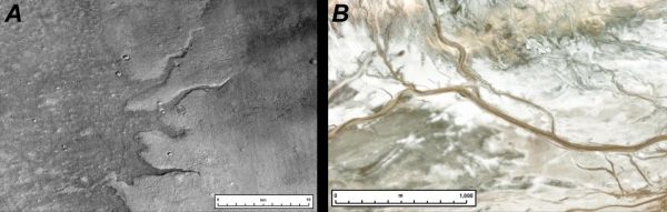
(A) A suite of ridges on Mars (at -67.64°E, 43.37°S). To determine whether features are ridges or valleys, the researchers rely on lighting in the impact craters (depressions). Based on the craters, the light is coming from the top of the image. Because the fluvial ridges are casting shadows to the south, they can infer that the feature is sticking up from the surface--a ridge rather than a valley. (B) A similar, "analogue" environment on Earth. Fluvial ridges similar to the ones on Mars are in California's Amargosa river system, although with water still running through the system, it's the active precursor to the ridges that are remnant on Mars. (Photo Credit: J. Dickson.)


