
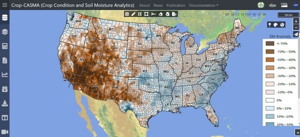
Crop-CASMA uses data from NASA missions to map soil moisture across the United States.
Farmers, researchers, meteorologists and others now have access to high-resolution NASA data on soil moisture, thanks to a new tool developed by the U.S. Department of Agriculture (USDA)’s National Agricultural Statistics Service (NASS) in collaboration with NASA and George Mason University.
The tool, Crop Condition and Soil Moisture Analytics (Crop-CASMA), provides access to high-resolution data from NASA’s Soil Moisture Active Passive (SMAP) mission and the Moderate Resolution Imaging Spectroradiometer (MODIS) instrument in a user-friendly format. Soil moisture data are critical for professionals in the agriculture and natural resources sectors who use soil moisture in tandem with other data to plan crop planting, forecast yields, track droughts or floods, and improve weather forecasts. Crop-CASMA is available for free online at https://cloud.csiss.gmu.edu/Crop-CASMA/.
The tool provides more thorough spatial coverage and consistency than other soil moisture measurement methods, said Rajat Bindlish, a research associate in Earth science remote sensing at NASA’s Goddard Space Flight Center in Greenbelt, Maryland.
Continue reading at NASA Goddard Space Flight Center
Image via NASA Goddard Space Flight Center


