
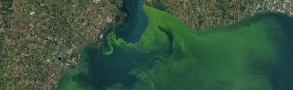
Satellites such as the NASA and USGS Landsat 8 can help scientists identify where an algal bloom has formed in lakes or rivers.
Fertilizers used in farming contain high amounts of nutrients, such as phosphorous, to help crops grow. But these same nutrients can cause unwanted plant growth and potentially harm ecosystems miles away if agricultural runoff flows into nearby rivers, lakes, or coastal waters.
These effects represent one of the many ways that the different parts of the Earth system are connected. Waterways like rivers and streams are natural highways that connect areas hundreds to thousands of miles apart. They are also essential ecosystems for fish and other aquatic life, as well as sources of drinking water and recreational areas for people. Earth-observing satellites from NASA and its partners have a unique perspective from which to study the links between water and other parts of the Earth system – and are uniquely poised to help researchers address the consequences of those links, namely water quality.
Most bodies of water contain microscopic, photosynthesizing organisms called cyanobacteria, which are harmless at normal levels. Individual cyanobacteria are tiny, visible only under a microscope. But certain conditions – lots of sunlight, stagnant water, and high amounts of nutrients like those in fertilizers – allow cyanobacteria populations to grow exponentially. The result is scummy green water that can be seen from space. These events, called harmful algal blooms, can lead to economic losses and poor water quality, and pose a health risk to humans and animals.
Continue reading at NASA Goddard Space Flight Center
Image via NASA Goddard Space Flight Center


