
Just weeks after the Pacific Northwest endured record-shattering temperatures, another heat wave scorched the U.S. Southwest.
Just weeks after the Pacific Northwest endured record-shattering temperatures, another heat wave scorched the U.S. Southwest. This heat wave, which started around July 7, tied or broke several all-time records in California, Nevada, northern Arizona, and southern Utah.
Two instruments – NASA’s Atmospheric Infrared Sounder (AIRS) aboard the Aqua satellite, and the agency’s ECOsystem Spaceborne Thermal Radiometer Experiment on Space Station (ECOSTRESS) – tracked the heat wave, providing visualizations of it.
The AIRS instrument captured the progression of a slow-moving heat dome across the southwestern U.S from July 1 to July 12. The animation of the AIRS data (above) shows surface air temperature anomalies – values above or below long-term averages. The hottest areas, shown in pink, experienced surface air temperatures more than 10 degrees Fahrenheit (5.6 degrees Celsius) above average. Surface air temperature is something that people directly feel when they are outside.
Read More: NASA Earth Science
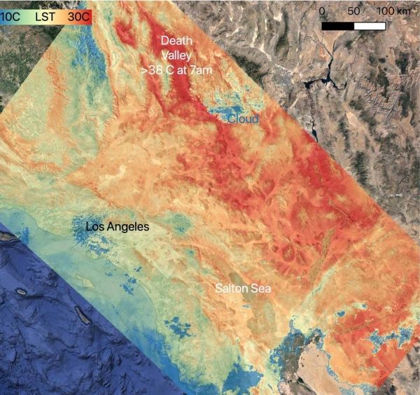
On July 8, 2021, NASA’s ECOSTRESS instrument, aboard the space station captured ground surface temperature data over California. Areas in red – including Death Valley – had surpassed 86 degrees Fahrenheit by 7:16 a.m. local time, well above average ground surface temperatures for the area. (Photo Credit: NASA/JPL-Caltech)


