
Smoke from several large wildfires burning in Northern California can be seen traveling miles into the atmosphere.
As of Aug. 24, wildfires in Northern California – including the McCash, Antelope, River Complex, Monument, and Dixie fires – have scorched more than 1 million acres of land.
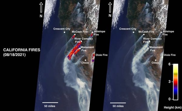
he Dixie Fire, the state’s second largest in history, accounts for 731,310 acres. On Aug. 18, NASA’s Multi-angle Imaging SpectroRadiometer (MISR) instrument, aboard the Terra satellite, acquired new data showing smoke from these fires.
The MISR instrument has nine cameras that view Earth at different angles. The right side of the image shows smoke from the five fires as observed by MISR’s nadir (downward-pointing) camera. The multi-angular information from MISR’s images is used to calculate the height of the smoke plumes. The results of those calculations are shown in the left side of the image.
Continue reading at NASA Jet Propulsion Laboratory
Image via NASA Jet Propulsion Laboratory


