
Satellite observations of nitrogen dioxide near key U.S. ports suggest that increased shipping activity and backlogs may be affecting air quality.
In October 2021, natural-color images from the Landsat and Terra satellites returned striking views of record-breaking backlogs of container ships idling offshore of some of America’s largest ports. Surging demand for consumer goods, labor and equipment shortages, and an array of COVID-related supply chain snarls have contributed to the backlogs.
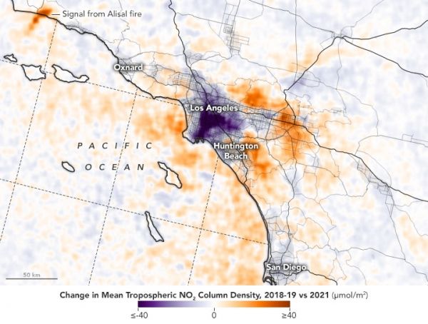
Now atmospheric scientists are working with air pollution data collected by satellites to find out whether the unusual shipping activity is affecting air quality near ports. Though other industries and processes may be playing a role, a preliminary look at satellite observations of nitrogen dioxide pollution offshore of ports suggests that shipping may be contributing to an uptick in pollution.
The maps above and below show the concentration of the air pollutant nitrogen dioxide (NO2) between October 1-23, 2021, as compared to the same period in 2019 and 2018 (before the COVID-19 pandemic upended global trade). The ports of Los Angeles, Long Beach, New York/New Jersey—the busiest ports in the United States—show apparent increases in NO2 in October 2021.
Continue reading at NASA Earth Observatory
Image via NASA Earth Observatory


