
Understanding when and where trees die in vast tropical forests is a challenging first step toward understanding carbon dynamics and climate change.
Understanding when and where trees die in vast tropical forests is a challenging first step toward understanding carbon dynamics and climate change. Researchers explained variations in tree mortality over a five-year period by analyzing drone images of one of the most-studied tropical forests in the world, Barro Colorado Island in Panama.
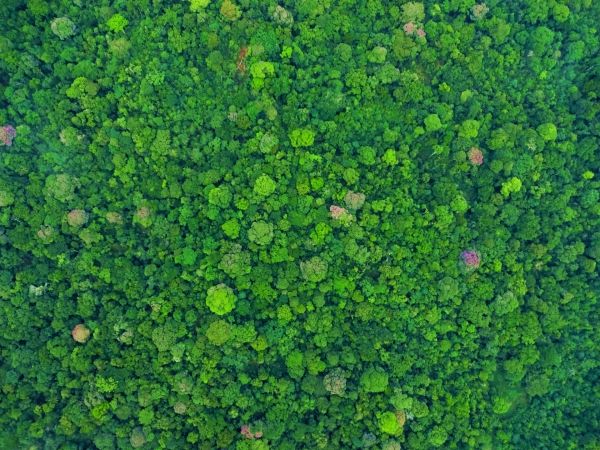
Imagine trying to understand how climate change affects vast tropical forests by determining how many trees die each year. Clouds get in the way of satellite views and on-the-ground estimates are expensive and impractical in remote areas. But researchers at the Smithsonian Tropical Research Institute (STRI) are excited by a new analysis that explains variation in tree mortality based on drone images of 1500 hectares of the most-studied tropical forest, Barro Colorado Island, in Panama.
There is concern that many large tropical trees will die as climate change intensifies processes that kill trees, like droughts and intense storms,” said KC Cushman, STRI post-doctoral fellow. “Large tropical trees contain a lot of carbon. When trees die and decompose, much of that carbon is released into the atmosphere, which could make climate change worse. However, for climate models to accurately predict whether more tropical trees will die, we need a better understanding of what conditions cause higher or lower tree mortality today. And that requires a reliable way to map tree mortality across large areas of forest.”
Read more at: Smithsonian Tropical Research Institute
Drone image of the tropical forest canopy of Barro Colorado Island, Panama. Researchers analyzed images taken over a five-year period to pinpoint when and where treefalls occur, important for understanding how climate change affects tropical forests. (Photo Credit: Smithsonian Tropical Research Institute)


