
In 2020, seismologist Göran Ekström noticed a peculiar wiggle picked up on Nov. 28 by seismographs around the world.
In 2020, seismologist Göran Ekström noticed a peculiar wiggle picked up on Nov. 28 by seismographs around the world. It emanated from a remote area in British Columbia’s steep, glaciated Central Coast Mountains, some 2,400 miles from Ekström’s office at Columbia University’s Lamont-Doherty Earth Observatory, in Palisades, N.Y.
“When I find something [that] looks a bit strange, I look at it more carefully,” said Ekström, who studies unusual seismic events. Conventional earthquakes usually begin with a big, high-frequency jolt, but this was not the case here. This was more of a low-frequency rumble that gradually accelerated before fading back—according to Ekström’s studies, the kind of signal produced by a big landslide. He emailed Marten Geertsema, a natural-hazards specialist with the BC provincial government. Seeing nothing in the news, Geertsema proceeded to scan recent satellite imagery of the area for signs of a disturbance, but couldn’t spot anything at first.
Around the same time, BC aviators heard about an unusual amount of wood floating in a fjord. They helicoptered in. Flying further up a river feeding the fjord, they saw countless mowed-down trees and a vast new wasteland of sand and gravel. Tracing up a side valley occupied by a stream called Elliot Creek, they found the source: the fresh scar of a gigantic landslide. It had hit a meltwater lake at the toe of the West Grenville Glacier and created a tsunami that devastated everything downstream. The scientists quickly connected the dots.
Read more at: Columbia Climate School
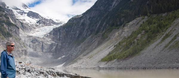
Scientists have linked a massive landslide in British Columbia to the recession of the West Grenville Glacier, seen at rear, along with slide debris. A resulting tsunami caused massive damage downstream. (Photo Credit: Briar Stewart)


