
From soaked to dry, the variable state of U.S. soils has implications for farmers and crop production.
After abundant rain and flooding in the Mississippi Valley and other regions in 2019, drought returned to much of the United States in 2021-22. From wet to dry, both extremes have implications for soils and the agriculture it supports.
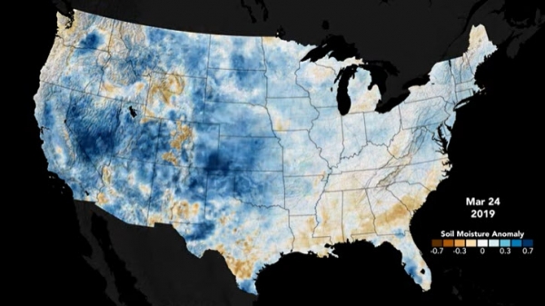
The opposing extremes were detected by NASA satellites. But it was a novel tool—the Soil Moisture Analytics (Crop-CASMA) product—that integrated this satellite data into a format that was particularly useful to people. With Crop-CASMA’s high-resolution, timely information on soil moisture, farmers and agriculture managers could track the areas of high and low moisture more closely.
The animations on this page, based on data from Crop-CASMA, show soil moisture anomalies in the top 10 centimeters (4 inches) of the ground across the conterminous United States. This surface layer, or topsoil, holds water used by plants in their earliest stages, from sprouts to seedlings. Too little or too much water during these phases of growth can mean trouble for crops.
Continue reading at NASA Earth Observatory
Image via NASA Earth Observatory


