
Several cities on the west coast of Florida lost much of their electric power for days after the storm.
On September 28–29, 2022, Hurricane Ian roared across Florida as one of the most potent storms ever to make landfall in the state. The category-4 hurricane brought sustained winds of 150 miles (240 kilometers) per hour and several feet of storm surge to the southwestern coast of Florida, before dropping more than a foot of rain in wide swaths across the state.
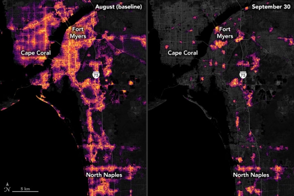
In the hours after the storm passed, millions of residential and business customers lost electric power and light. The Visible Infrared Imaging Radiometer Suite (VIIRS) on the NOAA–NASA Suomi NPP satellite captured views of some of those losses as they appeared on September 30, 2022.
The images above and below focus on the metropolitan areas of Fort Myers and Bradenton/Sarasota, which were among the worst-hit communities. VIIRS has a low-light sensor—the day-night band—that measures nighttime light emissions and reflections. Scientists with the Black Marble Project at NASA’s Goddard Space Flight Center, Science Systems and Applications, Inc. (SSAI), and the University of Maryland, College Park (UMD) processed VIIRS data to show lights before and after Ian passed through the cities. Data from September 30 were compared to a pre-storm composite (August) and overlaid on landcover data collected by Landsat 8 and 9.
Continue reading at NASA Earth Observatory
Image via NASA Earth Observatory


