
The world’s largest active volcano—Hawaii’s Mauna Loa—has been quiet for the past 38 years. But in 2022, the volcano began to stir, showing increased numbers of small earthquakes and subtle swelling of certain land surfaces in September.
The world’s largest active volcano—Hawaii’s Mauna Loa—has been quiet for the past 38 years. But in 2022, the volcano began to stir, showing increased numbers of small earthquakes and subtle swelling of certain land surfaces in September. On November 27, fountains of lava began spurting from the mountain’s Northeast Rift Zone and streams of molten rock flowed to the north.
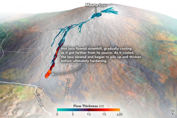
Ten days into the eruption, a NASA aircraft conducted its first flight over the erupting volcano. It carried NASA’s Uninhabited Aerial Vehicle Synthetic Aperture Radar (UAVSAR) system, which was used to map the volcano’s topography in fine detail with a Ka-band instrument called GLISTIN-A.
Teams from NASA’s Jet Propulsion Laboratory and the United States Geological Survey (USGS) used data from that sensor to map the thickness of those flows during a series of flights on December 7, 8, and 10. The map above shows the thickness of the lava flows during the flight on December 7, the day before USGS scientists noticed a significant decline in the pace of the eruption. A few days later, they declared the eruption had stopped. The map shows the thickness of the lava flows in the summit caldera, where the eruption began, and of lava flows on Mauna Loa’s northeastern flank. The color variation from blue to orange indicates increasing lava flow thickness. A maximum thickness of roughly 25 meters (82 feet) is shown, though values exceeding 40 meters (131 feet) were observed in some areas.
Read more at: NASA Earth Observatory
Photo Credit: NASA Earth Observatory


