
NASA has been working to better understand our home planet from the unique vantage point of space since the first TIROS satellites launched in the 1960s.
NASA has been working to better understand our home planet from the unique vantage point of space since the first TIROS satellites launched in the 1960s. Today, with more than two dozen Earth-observing satellites and instruments, it’s clearer than ever that our planet is an interconnected system. Local events can have global impacts and global events impact local communities. Recognizing that the challenges of today and tomorrow require an agencywide effort, NASA’s Office of the Chief Scientist established a cross-agency working group and released “Advancing NASA’s Climate Strategy.”
“The last nine years have been the hottest ever recorded. That is simply an indisputable fact, underscoring the need for bold action to protect our planet,” said Administrator Bill Nelson. “NASA’s climate strategy is a declaration of our continued commitment to lead on climate – and how we intend to do so.”
The strategy assesses NASA’s climate portfolio across the agency for the first time, extending beyond science and exploration efforts to include every mission directorate and NASA facility.
“The climate and Earth system are changing, and this impacts not only what science we need, but also how we think about our operations and mission safety,” said Kate Calvin, NASA’s chief scientist and senior climate advisor. “This strategy will help NASA integrate our understanding of climate across the agency and in our partnerships to better serve the public.”
Read more at NASA
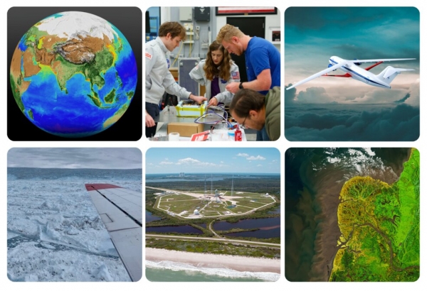
Image: Data visualization of measurements of life on land and the ocean from space; the Orion Labs team working on their NASA TechLeap Challenge project; illustration of a potential sustainable aircraft developed by NASA. From left lower row: Greenland’s Jakobshavn glacier, seen during flights of NASA’s Oceans Melting Greenland campaign; historic Launch Pad 39B at NASA’s Kennedy Space Center, where sea level is predicted to rise several inches in the coming years; the Yukon-Kuskowkwim Delta captured by Landsat 8, part of the Landsat series of satellites, which have been observing Earth for more than 50 years. (Credits: NASA)


