
To study ocean currents, scientists release GPS-tagged buoys in the ocean and record their velocities to reconstruct the currents that transport them.
To study ocean currents, scientists release GPS-tagged buoys in the ocean and record their velocities to reconstruct the currents that transport them. These buoy data are also used to identify “divergences,” which are areas where water rises up from below the surface or sinks beneath it.
By accurately predicting currents and pinpointing divergences, scientists can more precisely forecast the weather, approximate how oil will spread after a spill, or measure energy transfer in the ocean. A new model that incorporates machine learning makes more accurate predictions than conventional models do, a new study reports.
A multidisciplinary research team including computer scientists at MIT and oceanographers has found that a standard statistical model typically used on buoy data can struggle to accurately reconstruct currents or identify divergences because it makes unrealistic assumptions about the behavior of water.
Read more at: Massachusetts Institute of Technology
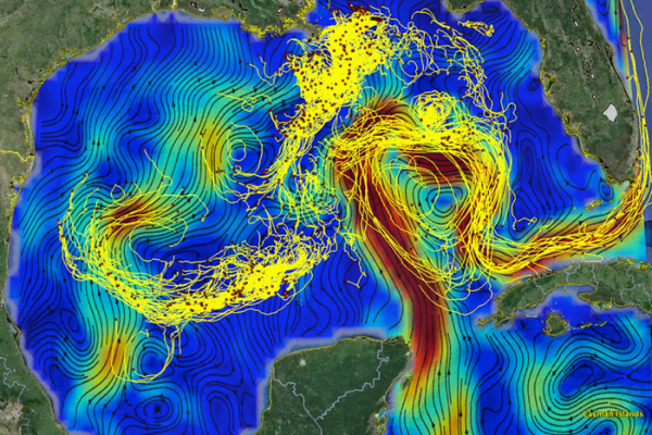
Computer scientists at MIT joined forces with oceanographers to develop a machine-learning model that incorporates knowledge from fluid dynamics to generate more accurate predictions about the velocities of ocean currents. This figure shows drifting buoy trajectories in the Gulf of Mexico superimposed on surface currents. The red dots mark the buoys’ positions on March 9, 2016, and the tails are 14 days long. (Photo Credit: Edward Ryan and Tamay Özgökmen from the University of Miami)


