
Researchers led by a team at the University of Wisconsin–Madison have created the first tool to map and visualize the areas where human settlements and nature meet on a global scale.
Researchers led by a team at the University of Wisconsin–Madison have created the first tool to map and visualize the areas where human settlements and nature meet on a global scale. The tool, which was part of a study recently published in Nature, could improve responses to environmental conflicts like wildfires, the spread of zoonotic diseases and loss of ecosystem biodiversity.
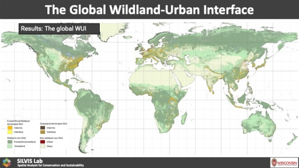
These areas where people and wildlands meet are called the wildland-urban interface, or WUI for short. More technically, a WUI (pronounced “woo-ee”) describes anywhere that has at least one house per 40 acres and is also 50% covered by wildland vegetation such as trees, shrubland, grassland, herbaceous wetland, mangroves, moss and lichen.
Franz Schug, a postdoctoral researcher in the Department of Forest and Wildlife Ecology at UW–Madison, explains that the areas were initially used by the U.S. Forest Service to assist with wildfire management in the Western United States.
Read more at University of Wisconsin-Madison
Image: Research led by UW–Madison’s SILVIS Lab have created the first map of wildland-urban interface areas around the globe. Their findings, recently published in Nature, provide detail about the kind of vegetation cover within each area. (Credit: University of Wisconsin–Madison)


