
Researchers from the University of Bonn are re-analyzing satellite data to calculate global water distribution.
Researchers from the University of Bonn are re-analyzing satellite data to calculate global water distribution.
While some parts of the world suffer extreme heat and persistent drought, others are being flooded. Overall, continental water volumes vary so much over time that global sea levels fluctuate significantly too. By combining the hydrological model WaterGAP with GRACE satellite data, a team of geodesists at the University of Bonn have come up with a new set of data that shows how the total distribution of water over the Earth’s land surfaces has changed over the past 20 years more accurately than ever before. Their findings are now being published in the “Journal of Geodesy.”
“The new method allows us to test out model calculations on the future effects of climate change, particularly how rising temperatures and changes in precipitation patterns will impact the water balance in different parts of the world,” says Prof. Dr.-Ing. Jürgen Kusche from the Institute of Geodesy and Geoinformation at the University of Bonn. The process involves comparing climate models, which invariably cover a certain period of time in the past, with the results of actual measurements, and Kusche and his team are planning several such studies over the coming months.
Read more at University of Bonn
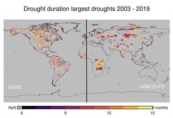
Image: Duration in months of the longest droughts (at least nine months) - over the past twenty years according to the new GLWS2.0 data (left) and the GRACE-FO satellite data (right). (Credit: © Illustration: Helena Gerdener via University of Bonn)


