
Like most people during the pandemic, Alex Kolker found himself with extra time on his hands.
Like most people during the pandemic, Alex Kolker found himself with extra time on his hands. A coastal geologist at the Louisiana Universities Marine Consortium, Kolker studies the Mississippi River Delta, and his work often involves surveying the watershed’s ever-changing wetlands and bays through the window of a small airplane. In 2021, with such research trips out of the question, Kolker did the next best thing — he conducted a flyover of the Delta on his computer screen, via satellite imagery. That was when he saw something peculiar.
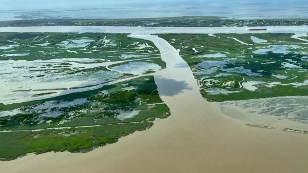
At a location about 70 river miles south of downtown New Orleans, adjacent to the small shrimping community of Buras, Kolker zoomed in on a large breach between the Mississippi and Breton Sound, the shallow saltwater bay that shapes the top of Louisiana’s foot. The cut, called Neptune Pass, was wide — too wide for Kolker not to have recognized it before.
To preserve the shipping channel and protect communities and infrastructure from flooding, the U.S. Army Corps of Engineers constantly dredges and maintains a more or less continuous levee system on both sides of the Mississippi throughout its Delta — except in the area of Neptune Pass. Here, where there is little human settlement and even less solid ground, the river’s east bank is relatively untouched. It’s also prone to breaching. Kolker wasn’t sure if Neptune Pass was a natural crevasse or manmade. But he knew that prior to 2019, it had been small — no wider than 150 feet.
Read more at: Yale Environment 360
Neptune Pass extends from the Mississippi River to Breton Sound, seen in the foreground. (Photo Credit: Alex Kolker/Southwings)


