
The international Surface Water and Ocean Topography mission is able to measure ocean features, like El Niño, closer to a coastline than previous space-based missions.
The international Surface Water and Ocean Topography mission is able to measure ocean features, like El Niño, closer to a coastline than previous space-based missions.
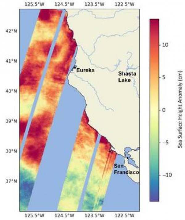
Warm ocean waters from the developing El Niño are shifting north along coastlines in the eastern Pacific Ocean. Along the coast of California, these warm waters are interacting with a persistent marine heat wave that recently influenced the development of Hurricane Hilary. The Surface Water and Ocean Topography (SWOT) satellite is able to spot the movement of these warm ocean waters in unprecedented detail.
A collaboration between NASA and the French space agency, CNES (Centre National d’Études Spatiales), SWOT is measuring the height of nearly all water on Earth’s surface, providing one of the most detailed, comprehensive views yet of the planet’s oceans and fresh water lakes and rivers.
Water expands as it warms, so sea levels tend to be higher in places with warmer water. El Niño – a periodic climate phenomenon that can affect weather patterns around the world – is characterized by higher sea levels and warmer-than-average ocean temperatures along the western coast of the Americas. The image above shows sea surface heights off the U.S. West Coast, near the California-Oregon border, in August. Red and orange indicate higher-than-average ocean heights, while blue and green represent lower-than-average heights.
Read more at NASA
Image: This data visualization shows sea surface heights off the northern California coast in August as measured by the Surface Water and Ocean Topography satellite. Red indicates higher-than-average heights, due to a marine heat wave and a developing El Niño, while blue signals lower-than-average heights. (Credits: NASA/JPL-Caltech)


