
Winter is coming—eventually. And while the earth is warming, a new study suggests that the atmosphere is being pushed around in ways that cause long bouts of extreme winter cold or wet in some regions.
Winter is coming—eventually. And while the earth is warming, a new study suggests that the atmosphere is being pushed around in ways that cause long bouts of extreme winter cold or wet in some regions.
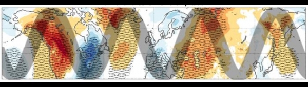
The study’s authors say they have identified giant meanders in the global jet stream that bring polar air southward, locking in frigid or wet conditions concurrently over much of North America and Europe, often for weeks at a time. Such weather waves, they say, have doubled in frequency since the 1960s. In just the last few years, they have killed hundreds of people and paralyzed energy and transport systems.
“Even though winters are getting milder on average, it’s happening at the expense of increasingly devastating heat extremes in the warm season,” said author Kai Kornhuber, an adjunct scientist at Columbia University’s Lamont-Doherty Earth Observatory. “A hundred years from now, we will probably not have to worry as much about extreme cold, because everything is getting warmer. But today and going forward, cold is still a very relevant hazard.”
Read more at: Columbia Climate School
An idealized illustration of giant meanders in the global jet stream known as wave-4 patterns, which are bringing extreme winter cold and/or precipitation (blue areas) to parts of North America and Europe. (Photo Credit: Kai Kornhuber)


