
An ephemeral lake in Death Valley’s Badwater Basin is showing its staying power.
An ephemeral lake in Death Valley’s Badwater Basin is showing its staying power. After forming in August 2023 in the aftermath of Hurricane Hilary, the lake gradually shrank but persisted throughout the fall and winter. A potent atmospheric river filled it back up in February 2024.
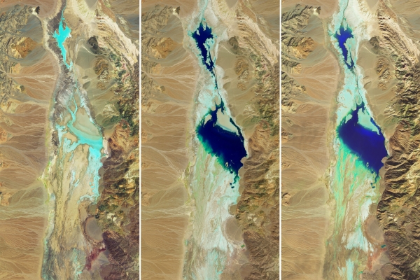
This series of images compares the desert basin before flooding (left) with its more-waterlogged state following each major storm. In both August 2023 (middle) and February 2024 (right), a shallow lake several kilometers across fills in the low-lying salt flat. The images were acquired by the OLI (Operational Land Imager) sensor on Landsat 8 (left and right) and the OLI-2 on Landsat 9 (middle). They are false-color, shown with the OLI and OLI-2 band combination of 6-5-3, which emphasizes the presence of water in shades of blue.
The driest place in North America, Death Valley typically receives about 2 inches (51 millimeters) of rain per year. However, in the past six months alone, more than double that—4.9 inches (125 millimeters)—fell at the national park’s official weather gauge at Furnace Creek. Two events were responsible for most of that precipitation. The remnants of Hurricane Hilary delivered 2.2 inches on August 20, 2023, and an atmospheric river brought another 1.5 inches from February 4–7, 2024, according to park officials.
Read more at NASA Earth Observatory
Image: Refreshed by precipitation from an atmospheric river, a temporary lake in Death Valley is extending its stay. (NASA Earth Observatory images by Wanmei Liang, using Landsat data from the U.S. Geological Survey)


