
In many parts of the U.S. East Coast, rising seas driven by melting ice and the thermal expansion of warming water is only part of what threatens coastal areas.
In many parts of the U.S. East Coast, rising seas driven by melting ice and the thermal expansion of warming water is only part of what threatens coastal areas. The land is also sinking. This geologic two-step is happening rapidly enough to threaten infrastructure, farmland, and wetlands that tens of millions of people along the coast rely upon, according to a NASA-funded team of scientists at Virginia Tech’s Earth Observation and Innovation (EOI) Lab.
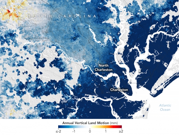
The researchers analyzed satellite data and ground-based GPS sensors to map the vertical and horizontal motion of coastal land from New England to Florida. In a study published in PNAS Nexus, the team reported that more than half of infrastructure in major cities such as New York, Baltimore, and Norfolk is built on land that sank, or subsided, by 1 to 2 millimeters per year between 2007 and 2020. Land in several counties in Delaware, Maryland, South Carolina, and Georgia sank at double or triple that rate. At least 867,000 properties and critical infrastructure including several highways, railways, airports, dams, and levees were all subsiding, the researchers found.
The findings follow a previous study from the EOI Lab, published in Nature Communications, that used the same data to show that most East Coast marshes and wetlands—critical for protecting many cities from storm surge during hurricanes—were sinking by rates exceeding 3 millimeters per year. They found that at least 8 percent of coastal forests had been displaced due to subsidence and saltwater intrusion, leading to a proliferation of “ghost forests.”
Read more at NASA Earth Observatory
Image: NASA Earth Observatory images by Lauren Dauphin, using data from Ohenhen, Leonard O., et al. (2023).


