
In the waters around Antarctica, ice coverage in 2024 shrank to near-historic lows for the third year in a row.
In the waters around Antarctica, ice coverage in 2024 shrank to near-historic lows for the third year in a row. The recurring loss hints at a long-term shift in conditions in the Southern Ocean, scientists say.
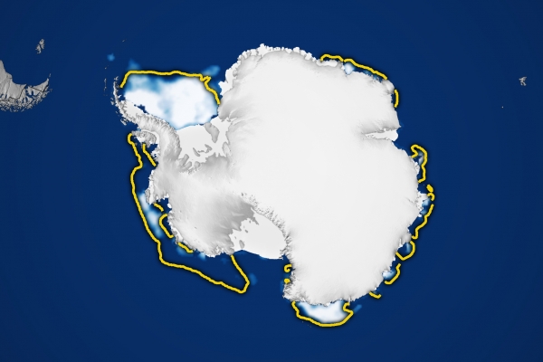
Antarctic sea ice reached its lowest annual extent on February 20, 2024, with a total of 1.99 million square kilometers (768,000 square miles). That’s 30 percent below the 1981 to 2010 end-of-summer average—a difference in ice cover that spans an area about the size of Texas.
Scientists with NASA and the National Snow and Ice Data Center (NSIDC) at the University of Colorado, Boulder, track these seasonal and annual fluctuations because sea ice shapes Earth’s polar ecosystems and plays a significant role in global climate.
The map above shows the ice extent on February 20, the day of the annual minimum extent. To determine extent, scientists project satellite observations of sea ice onto a grid and then add up the total area of each cell that is at least 15 percent ice-covered. The yellow outline shows the median sea ice extent for February from 1981 to 2010. A median is the middle value; that is, half of the extents were larger than the yellow line and half were smaller.
Read more at NASA Earth Observatory
Image: NASA Earth Observatory images by Lauren Dauphin, using data from the National Snow and Ice Data Center.


