
A NASA sensor recently brought a new approach to battling wildfire, providing real-time data that helped firefighters in the field contain a blaze in Alabama.
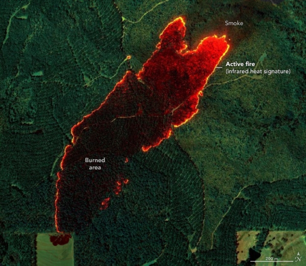
A NASA sensor recently brought a new approach to battling wildfire, providing real-time data that helped firefighters in the field contain a blaze in Alabama. Called AVIRIS-3 (Airborne Visible Infrared Imaging Spectrometer 3), the instrument detected a 120-acre fire on March 19 that had not yet been reported to officials.
As AVIRIS-3 flew aboard a King Air B200 research plane over the fire about 3 miles (5 kilometers) east of Castleberry, Alabama, a scientist on the plane analyzed the data in real time and identified where the blaze was burning most intensely. The information was then sent via satellite internet to fire officials and researchers on the ground, who distributed images showing the fire’s perimeter to firefighters’ phones in the field.
All told, the process from detection during the flyover to alert on handheld devices took a few minutes. In addition to pinpointing the location and extent of the fire, the data showed firefighters its perimeter, helping them gauge whether it was likely to spread and decide where to add personnel and equipment.
Read more at NASA Earth Observatory
Image: NASA Earth Observatory images annotated by Lauren Dauphin using AVIRIS-3 data via the AVIRIS Data Portal.


