
Using a brand-new type of satellite altimetry, a study led by Oxford University has finally confirmed the theory that the cause of extraordinary global tremors in September - October 2023 was indeed two mega tsunamis in Greenland that became trapped standing waves.
Using a brand-new type of satellite altimetry, a study led by Oxford University has finally confirmed the theory that the cause of extraordinary global tremors in September - October 2023 was indeed two mega tsunamis in Greenland that became trapped standing waves. The findings have been published today in Nature Communications.
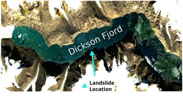
In September 2023, a bizarre global seismic signal was observed which appeared every 90 seconds over nine days – and was then repeated a month afterwards. Almost a year later, two scientific studies proposed that the cause of these seismic anomalies were two mega tsunamis which were triggered in the remote Dickson fjord in East Greenland by two major landslides which occurred due to warming of an unnamed glacier. The waves were thought to have become trapped in the fjord system, forming standing waves (or seiches) that undulated back and forth, causing the mystery signals.
However, up to now no observations of these seiches existed to confirm this theory. Even a Danish military vessel which visited the fjord three days into the first seismic event did not observe the wave which was shaking the Earth.
In the new study, the Oxford researchers used novel analysis techniques to interpret satellite altimetry data. This measures the height of the Earth’s surface (including the ocean) by recording how long it takes for a radar pulse to travel from a satellite to the surface and back again. Up to now, conventional satellite altimeters were not able to capture evidence of the wave due to long gaps between observations, and the fact that they sample data directly beneath the spacecraft, producing 1D profiles along the sea surface. This makes them incapable of depicting the differences in water height needed to spot the waves.
Read more at University of Oxford
Image: Copernicus Sentinel-2 satellite image of the Dickson Fjord in East Greenland. Credit: Thomas Monahan. (Credit: Thomas Monahan)


