
Amid a spate of severe weather across the U.S. Midwest, Southeast, and Mid-Atlantic regions on May 16, 2025, a deadly tornado tore across three counties in Kentucky.
Amid a spate of severe weather across the U.S. Midwest, Southeast, and Mid-Atlantic regions on May 16, 2025, a deadly tornado tore across three counties in Kentucky. It was one of the strongest tornadoes ever recorded in the area, according to the National Weather Service (NWS) office in Jackson, Kentucky. The NWS assessment found that the path of damage extended nearly 56 miles (90 kilometers) and reached a maximum width of nearly a mile (1.6 kilometers).
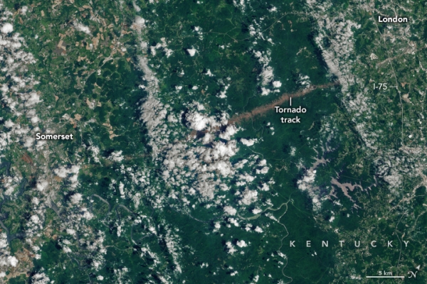
The OLI-2 (Operational Land Imager-2) on Landsat 9 acquired these images of part of the tornado’s scar on June 4, 2025—the first mostly cloud-free Landsat scene since the event. (Note that the image is slightly rotated to include more of the track.) The tornado touched down near the community of Whittle, about 20 miles west of Somerset, around 10:30 p.m. local time on May 16; it lifted just east of London shortly before midnight.
An NWS analysis indicates that the tornado peaked as an EF-4—the second-highest rating on the Enhanced Fujita (EF) scale, which derives wind speeds based on observed damage. Estimated wind speeds during this event reached as high as 170 miles (274 kilometers) per hour. Some of the most serious destruction occurred along the part of the path shown in the image above, according to damage survey data.
Read more at NASA Earth Observatory
Image: NASA Earth Observatory image by Wanmei Liang, using Landsat data from the U.S. Geological Survey.


