
A powerful storm system brought wintry conditions to Lesotho and South Africa in early June 2025.
A powerful storm system brought wintry conditions to Lesotho and South Africa in early June 2025. Snow blanketed higher elevations, while strong winds, cold temperatures, and heavy rains affected lower-elevation and coastal areas.
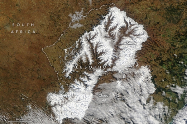
The severe weather was fueled by a cut-off low, which occurs when an area of low pressure becomes cut off from the jet stream. The weather system parked over central and eastern South Africa and Lesotho on June 9 and 10. The storm had subsided by June 11, when the MODIS (Moderate Resolution Imaging Spectroradiometer) on NASA’s Terra satellite acquired these images.
The left image shows the area in natural color, while the right image is false-color to help distinguish the snow (light blue) from clouds (white). (Note that small ice crystals in high-level clouds can also display a bluish tinge.) Fresh snow covers much of Lesotho, as well as portions of South Africa’s Eastern Cape and KwaZulu-Natal provinces. The snow created treacherous driving conditions and prompted closures of several sections of highway, according to news reports.
Read more at NASA Earth Observatory
Image: NASA Earth Observatory image by Lauren Dauphin, using MODIS data from NASA EOSDIS LANCE and GIBS/Worldview.


