
A dataset unveiled today more than doubles the documented stream miles in the Chesapeake Bay Watershed, elevating the total from approximately 100,000 to over 200,000 miles.
A dataset unveiled today more than doubles the documented stream miles in the Chesapeake Bay Watershed, elevating the total from approximately 100,000 to over 200,000 miles. The Hyper-Resolution Hydrography Data used to generate the new stream maps stems from a collaboration between the University of Maryland, Baltimore County (UMBC), the Environmental Protection Agency’s Chesapeake Bay Program (CBP), and the Chesapeake Conservancy (CC), including UMBC alumni at CBP and CC.
The project lays a robust foundation for sustainable management of one of North America’s most critical ecosystems, which spans six states and supports millions of residents and iconic wildlife, such as blue crabs and migrating shorebirds. The new, high-resolution dataset offers the clearest picture yet of how water moves through both pristine landscapes and altered terrain throughout the watershed.
The novel, AI-supported mapping method the research team used also dramatically reduces costs, time, and labor required for stream mapping, making it easy to update as additional data become available or apply in other watersheds to amplify its impact.
“The landscape is shaped by running water. Stream networks are the primary conduit between the watershed and the Bay, and now we can characterize that connection in ways that we’ve never been able to before,” says Matthew Baker, UMBC professor of geography and environmental systems, and a lead on the mapping project. In addition to locating streams and tracing their flow paths with a high degree of precision, the mapping process also allowed the team to report estimates of each channel’s width and depth along its entire length.
Read more at University of Maryland Baltimore County
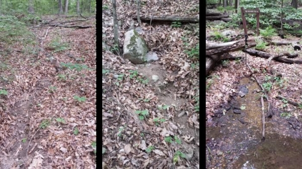
Image: These streams were all missed by older stream maps of the Chesapeake Bay Watershed, but they were detected by a new, AI-supported stream mapping method that is also less expensive and much faster. The new public dataset was released on June 26, 2025 and can be used by anyone to prioritize restoration efforts. (Credit: David Saavedra)


