
Several large wildland fires burned in Northern California in mid-July 2025 amid exceptional heat and low humidity.
Several large wildland fires burned in Northern California in mid-July 2025 amid exceptional heat and low humidity. Notable blazes included the Green and Butler fires, visible in images captured by the OLI (Operational Land Imager) on the Landsat 8 satellite on July 13.
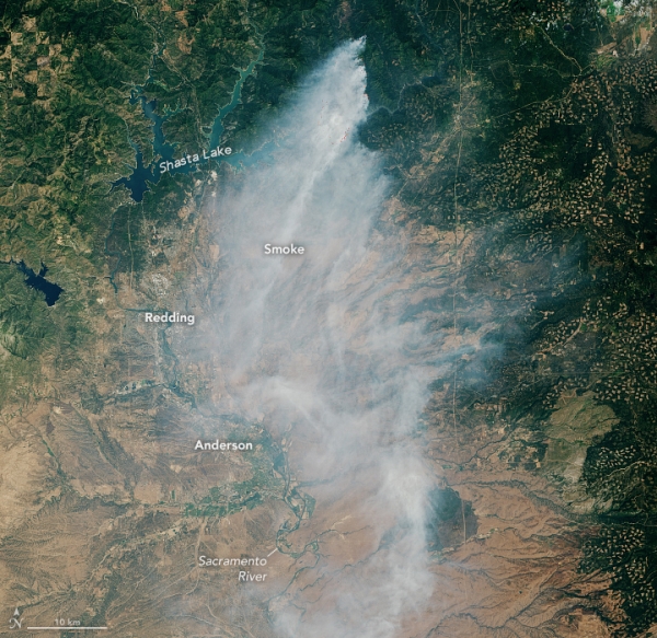
On July 1, lightning ignited the Green fire north of the Pit River arm of Shasta Lake. By the date Landsat acquired these images, the blaze had grown to 10,334 acres (4,182 hectares), according to the U.S. Forest Service. The wide view above shows smoke billowing south, contributing to unhealthy air quality around the lake and in communities along the Sacramento River from Redding to Anderson, according to the interagency air quality monitoring tool AirNow. The second image below shows a detailed view of the active fire area; bright orange indicates the infrared signature of actively burning fires.
Meanwhile, approximately 120 kilometers (75 miles) to the northwest, the Butler fire was burning in the Six Rivers National Forest east of Orleans. When Landsat 8 captured this image (below) on July 13, the blaze had burned 7,203 acres, according to the U.S. Forest Service. Smoke plumes billowed toward the west over Orleans and had also wafted over regions east of the blaze. NASA’s TEMPO (Tropospheric Emissions: Monitoring of Pollution) sensor also observed nitrogen dioxide air pollution from the fire throughout the day.
Read more at NASA Earth Observatory
Image: NASA Earth Observatory images by Lauren Dauphin, using Landsat data from the U.S. Geological Survey.


