
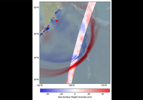
The SWOT (Surface Water and Ocean Topography) satellite captured the tsunami spawned by an 8.8 magnitude earthquake off the coast of Russia’s Kamchatka Peninsula on July 30, 11:25 a.m. local time.
The SWOT (Surface Water and Ocean Topography) satellite captured the tsunami spawned by an 8.8 magnitude earthquake off the coast of Russia’s Kamchatka Peninsula on July 30, 11:25 a.m. local time. The satellite, a joint effort between NASA and the French space agency CNES (Centre National d’Études Spatiales), recorded the tsunami about 70 minutes after the earthquake struck.
Disturbances like an earthquake or underwater landslide trigger a tsunami when the event is large enough to displace the entire column of seawater from the ocean floor to the surface. This results in waves that ripple out from the disturbance much like dropping a pebble into a pond generates a series of waves.
“The power of SWOT’s broad, paintbrush-like strokes over the ocean is in providing crucial real-world validation, unlocking new physics, and marking a leap towards more accurate early warnings and safer futures,” said Nadya Vinogradova Shiffer, NASA Earth lead and SWOT program scientist at NASA Headquarters in Washington.
Read More: National Aeronautics and Space Administration (NASA)
Image: The SWOT satellite caught the leading edge of the tsunami wave (red) that rolled through the Pacific Ocean on July 30. Sea level data, shown in the highlighted swath, is plotted against a NOAA tsunami forecast model in the background. A red star marks the location of the earthquake that spawned the tsunami.
NASA/JPL-Caltech


