
Thousands of Americans are impacted each summer by excessive heat and humidity, some suffering from heat-related illnesses when the body can’t cool itself down.
Thousands of Americans are impacted each summer by excessive heat and humidity, some suffering from heat-related illnesses when the body can’t cool itself down. Data from NASA satellites could help local governments reduce the sweltering risks, thanks to a collaboration between NASA scientists and officials in Prince George’s County, Maryland. The effort demonstrates how local officials in other communities could turn to NASA data to inform decisions that provide residents with relief from summer heat.
NASA researchers and their Prince George’s County collaborators reported in Frontiers in Environmental Science that they used the Landsat 8 satellite, jointly operated by NASA and the US Geological Survey, and NASA’s Aqua satellite, to gain insight into surface temperature trends across the county over the past few decades. The data also show how temperatures have responded to changing land use and construction. It is information that county planners and environmental experts hope can aid them in their attempts to remediate and prevent heat dangers in the future. The collaboration may also help the county’s first responders anticipate and prepare for heat-related emergencies and injuries.
Cooperation with Prince George’s County expands on NASA’s historic role, said Stephanie Schollaert Uz, an applications scientist with NASA’s Goddard Space Flight Center in Greenbelt, Maryland, and one of the study authors. “Applying government satellite data to county-level problems is new here. We’re trying to make it easier for people outside of NASA to use our data, in part by including how-to guides referenced at the end of our paper,” Schollaert Uz said.
Read more at: NASA Goddard Space Flight Center
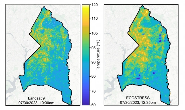
These maps of Prince George’s County, MD, show surface temperatures collected a few hours apart on July 30, 2023 from the Landsat 9 satellite and the ECOsystem Spaceborne Thermal Radiometer Experiment on Space Station (ECOSTRESS) instrument. The dark blue spots in the right hand image are likely clouds that formed in the afternoon. (Photo Credit: Stephanie Schollaert Uz, NASA Goddard Space Flight Center)


