
Ice covers about 1.7 million square kilometers (656,000 square miles) of Greenland, forming the largest ice sheet on Earth outside of Antarctica.
Ice covers about 1.7 million square kilometers (656,000 square miles) of Greenland, forming the largest ice sheet on Earth outside of Antarctica. Each summer, its surface begins to melt under the warmth of the Sun, intensified by the season’s long daylight hours and sometimes further enhanced by clouds and rain.
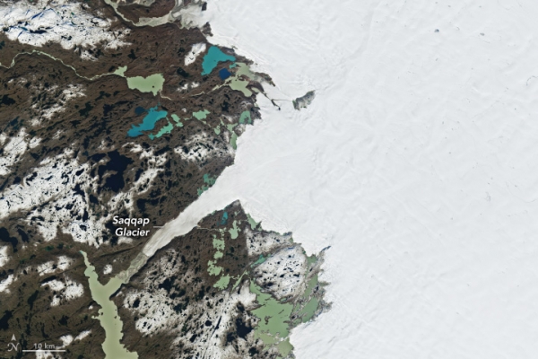
Greenland’s melting season usually runs from May to early September. The 2025 season was considered “moderately intense,” ranking 19th in the 47-year satellite record for cumulative daily melt area as of late August, according to an analysis by the National Snow and Ice Data Center (NSIDC). This year’s season featured an extended period of melting in part of July and a sharp increase in warmth and melting in mid-August.
The mid-August spike, which was preceded by significant rainfall in some areas, peaked on August 21, when melting was observed across nearly 35 percent of the ice sheet—a record for that date, according to the NSIDC. These satellite images show the ice sheet on that day (left) and nearly two weeks later (right), along part of its southwestern edge about 150 kilometers (90 miles) northeast of the capital city of Nuuk (not shown). Both images were captured by the OLI-2 (Operational Land Imager-2) on Landsat 9.
Read More: NASA
Image: NASA Earth Observatory images by Wanmei Liang, using Landsat data from the U.S. Geological Survey.


