
Tropical cyclones almost never form over the Strait of Malacca.
Tropical cyclones almost never form over the Strait of Malacca. The narrow waterway separating Peninsular Malaysia from the Indonesian island of Sumatra sits so close to the equator that the Coriolis effect is usually too weak to allow storms to rotate enough to organize into cyclones. But on November 25, 2025, meteorologists watched as a tropical depression intensified into Cyclone Senyar—just the second documented case of a tropical cyclone forming in the strait.
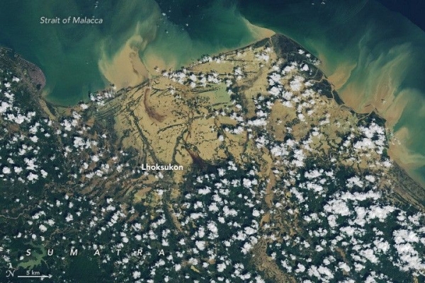
Hemmed in by land on both sides, Senyar made landfall in Sumatra later that day as it made a U-turn and headed east toward Malaysia. As the slow-moving storm passed over Sumatra’s mountainous terrain, it dropped nearly 400 millimeters (16 inches) of rain in many areas, according to satellite-based estimates from NASA’s Global Precipitation Measurement (GPM) mission. (Due to the averaging of the satellite data, local rainfall amounts may differ when measured from the ground.)
The torrent caused extensive flash floods and landslides in Sumatra’s rugged terrain. Streams and rivers rapidly overflowed with sediment-laden, debris-filled waters that swept through villages, cities, and towns. News reports suggest that the damage was worsened by an earthquake that struck on November 27 and the abundance of loose piles of timber in the region that became destructive battering rams in high water. As of December 4, Indonesian authorities reported several hundred deaths and more than 700,000 displaced people.
Read more at: NASA
Photo Credit: Lauren Dauphin, using Landsat data from the U.S. Geological Survey.


