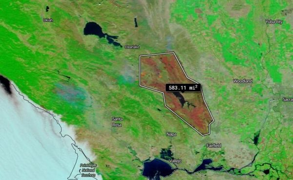
On Aug. 26, 2020, NASA’s Terra satellite was able to image the two areas in California where the fires have been most active and using the false color reflectance bands on the MODIS (Moderate Resolution Infrared Spectroradiometer) instrument aboard.
On Aug. 26, 2020, NASA’s Terra satellite was able to image the two areas in California where the fires have been most active and using the false color reflectance bands on the MODIS (Moderate Resolution Infrared Spectroradiometer) instrument aboard.

It wasn't long after Hurricane Laura hit the Gulf Coast Thursday that people began flying drones to record the damage and posting videos on social media.

N95 respirators, which are widely worn by health care workers treating patients with COVID-19 and are designed to be used only once, can be decontaminated effectively and used up to three times, according to research by UCLA scientists and colleagues.

Nighttime imagery from NASA-NOAA’s Suomi NPP satellite revealed the Eastern Pacific Ocean’s Tropical Storm Hernan along the coast of western Mexico. By the weekend, Hernan is expected to absorb nearby Tropical Storm Iselle.

Global warming is dramatically increasing the risk of extreme hurricanes in the Caribbean, but meeting more ambitious climate change goals could up to halve the likelihood of such disasters in the region, according to new research.

Researchers at the University of Alberta are preparing to launch clinical trials of a drug used to cure a deadly disease caused by a coronavirus in cats that they expect will also be effective as a treatment for humans against COVID-19.


