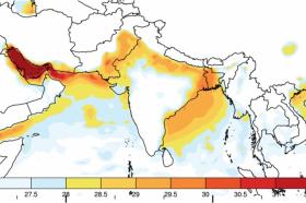
In South Asia, a region of deep poverty where one-fifth of the world’s people live, new research suggests that by the end of this century climate change could lead to summer heat waves with levels of heat and humidity that exceed what humans can survive without protection.
There is still time to avert such severe warming if measures are implemented now to reduce the most dire consequences of global warming. However, under business-as-usual scenarios, without significant reductions in carbon emissions, the study shows these deadly heat waves could begin within as little as a few decades to strike regions of India, Pakistan, and Bangladesh, including the fertile Indus and Ganges river basins that produce much of the region’s food supply.
>> Read the Full Article
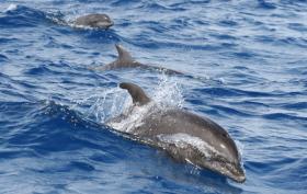
The health of dolphin populations worldwide depends on sustained access to robust food sources.
A new report by UC Santa Barbara researchers and colleagues at UC San Diego and the National Oceanic and Atmospheric Administration looks at three different dolphin species, studying what they eat and how they divide ocean resources and space -- important information for conservation and management. The team's findings appear in the journal PLOS ONE.
"We used the principle of 'you are what you eat' to unlock some of the secrets of dolphin diet," said lead author Hillary Young, an assistant professor in UCSB's Department of Ecology, Evolution, and Marine Biology (EEMB). "All of the foods that we or any animal eat are incorporated after digestion into body tissues. Most Americans, for example, chemically look like walking corn cobs because the foods we eat contain so much corn syrup."
>> Read the Full Article
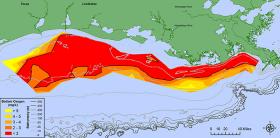
Scientists have determined this year’s Gulf of Mexico “dead zone,” an area of low oxygen that can kill fish and marine life, is 8,776 square miles, an area about the size of New Jersey. It is the largest measured since dead zone mapping began there in 1985.
The measured size is close to the 8,185 square miles forecast by NOAA in June.
>> Read the Full Article
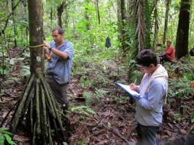
The past few decades have seen the rise of global incentive programs offering payments to landowners to help reduce tropical deforestation. Until now, assessments of these programs have largely overlooked decreases in forest diversity. In what might be a first of its kind study, University of Missouri researchers have integrated forest imaging with field-level inventories and landowner surveys to assess the impact of conservation payments in Ecuador’s Amazon Basin forests. They found that conservation payment programs are making a difference in the diversity of tree species in protected spaces. Further, the species being protected are twice as likely to be of commercial timber value and at risk of extinction.
>> Read the Full Article
Producers sometimes face challenges that go deep into the soil. They need answers to help the soil, on site. A portable field sensor can accurately measure minerals in soils more easily and efficiently than existing methods. And a research team, including a middle school student and her scientist father, can confirm it.
>> Read the Full Article
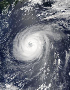
NASA’s Aqua satellite is keeping track of Typhoon Noru as it continues its slow trek through the Northwestern Pacific Ocean.
On August 2, 2017 at 12:05 a.m. EDT (0405 UTC) the Moderate Resolution Imaging Spectroradiometer or MODIS instrument that flies aboard NASA’s Aqua satellite captured a visible image of Typhoon Noru. The MODIS image shows a symmetric band of thunderstorms completely surrounding a well-defined eye feature.
>> Read the Full Article


