
Using a first-of-its-kind, high-resolution numerical model to describe ocean circulation during the last ice age about 21,000 year ago, oceanographer Alan Condron of the University of Massachusetts Amherst has shown that icebergs and meltwater from the North American ice sheet would have regularly reached South Carolina and even southern Florida. The models are supported by the discovery of iceberg scour marks on the sea floor along the entire continental shelf. Such a view of past meltwater and iceberg movement implies that the mechanisms of abrupt climate change are more complex than previously thought, Condron says. "Our study is the first to show that when the large ice sheet over North America known as the Laurentide ice sheet began to melt, icebergs calved into the sea around Hudson Bay and would have periodically drifted along the east coast of the United States as far south as Miami and the Bahamas in the Caribbean, a distance of more than 3,100 miles, about 5,000 kilometers."
Using a first-of-its-kind, high-resolution numerical model to describe ocean circulation during the last ice age about 21,000 year ago, oceanographer Alan Condron of the University of Massachusetts Amherst has shown that icebergs and meltwater from the North American ice sheet would have regularly reached South Carolina and even southern Florida. The models are supported by the discovery of iceberg scour marks on the sea floor along the entire continental shelf.
!ADVERTISEMENT!
Such a view of past meltwater and iceberg movement implies that the mechanisms of abrupt climate change are more complex than previously thought, Condron says. "Our study is the first to show that when the large ice sheet over North America known as the Laurentide ice sheet began to melt, icebergs calved into the sea around Hudson Bay and would have periodically drifted along the east coast of the United States as far south as Miami and the Bahamas in the Caribbean, a distance of more than 3,100 miles, about 5,000 kilometers."
His work, conducted with Jenna Hill of Coastal Carolina University, is described in the current advance online issue of Nature Geosciences. "Determining how far south of the subpolar gyre icebergs and meltwater penetrated is vital for understanding the sensitivity of North Atlantic Deep Water formation and climate to past changes in high-latitude freshwater runoff," the authors say.
Hill analyzed high-resolution images of the sea floor from Cape Hatteras to Florida and identified about 400 scour marks on the seabed that were formed by enormous icebergs plowing through mud on the sea floor. These characteristic grooves and pits were formed as icebergs moved into shallower water and their keels bumped and scraped along the ocean floor.
"The depth of the scours tells us that icebergs drifting to southern Florida were at least 1,000 feet, or 300 meters thick," says Condron. "This is enormous. Such icebergs are only found off the coast of Greenland today."
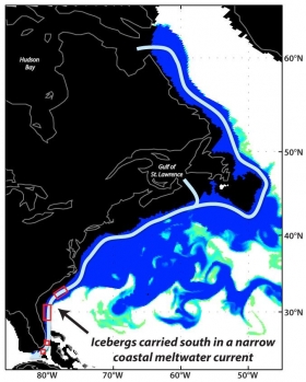
To investigate how icebergs might have drifted as far south as Florida, Condron simulated the release of a series of glacial meltwater floods in his high-resolution ocean circulation model at four different levels for two locations, Hudson Bay and the Gulf of St. Lawrence.
Image shows map of the pathway taken by icebergs from Hudson Bay, Canada, to Florida. The blue colors (behind the arrows) are an actual snapshot from the authors' high resolution model showing how much less salty the water is than normal. The more blue the color the less salty it is than normal. In this case, blue all the way along the coast shows that very fresh, cold waters are flowing along the entire east coast from Hudson Bay to Florida.
Credit: UMass Amherst
Read more at EurekAlert.


