
NASA analyzed a major tropical cyclone spinning in the Southwestern Indian Ocean and measured its rainfall.
On January 27, Tropical Cyclone Cebile formed in the southwest Indian Ocean southeast of Diego Garcia. On January 31, Tropical Cyclone Cebile became the most powerful tropical cyclone to form in the southern hemisphere this year. Maximum sustained wind speeds were estimated at 120 knots (138 mph) early in the day making Cebile the equivalent of a category 4 hurricane on the Saffir-Simpson hurricane wind scale.
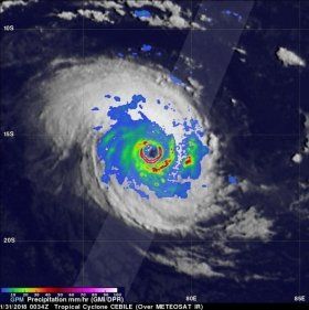
The GPM core observatory satellite passed directly above the well-defined circular eye of Tropical Cyclone Cebile on January 31, 2018 at 0034 UTC. Rainfall intensity and coverage within Cebile were revealed by GPM's Microwave Imager (GMI) and Dual Frequency Precipitation Radar (DPR) instruments. GPM's GMI and DPR showed that intense thunderstorms on the southern side of Cebile's nearly clear eye were dropping rain at a rate of more than 228 mm (9 inches) per hour.
Read more at NASA/Goddard Space Flight Center
Image: On Jan. 31, GPM showed that intense thunderstorms on the southern side of Cebile's nearly clear eye were dropping rain at a rate of more than 228 mm (9 inches) per hour. (Credit: NASA/JAXA, Hal Pierce)


