
Tropical Storm Sanba, formerly known as 02W has triggered many warnings in the Philippines as it approaches from the east. NASA-NOAA's Suomi NPP satellite provided forecasters with a visible image of the storm.
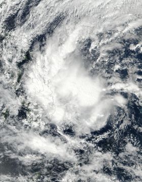
On Feb. 12 at 12:12 a.m. EST (0512 UTC), the Visible Infrared Imaging Radiometer Suite (VIIRS) instrument aboard NASA-NOAA's Suomi NPP satellite captured a visible image of Sanba. A fragmented band of thunderstorms in the western quadrant of the tropical storm was over the central and southern Philippines. The strongest convection and thunderstorms appeared north and east of the low-level center of circulation over the Philippine Sea. The image was created at NASA's Goddard Space Flight Center in Greenbelt, Md.
Many warnings are in effect in the Philippines: tropical cyclone warning signal #2 is in force for the Mindanao provinces of Dinagat Island, Surigao del Norte, Surigao del Sur, Agusan del Norte, Agusan del Sur, Camiguin, Misamis Oriental, and northern section of Bukidnon.
Read more at NASA/Goddard Space Flight Center
Image: On Feb. 12 at 12:12 a.m. EST (0512 UTC), a visible image of Tropical Storm Sanba was acquired from the VIIRS instrument aboard NASA-NOAA's Suomi NPP satellite as it continued moving over the Philippines. (Credit: NOAA/NASA Rapid Response Team)


