
Tropical Storm Chris was strengthening when NASA’s Aqua satellite passed over the U.S. Eastern Seaboard on July 9. Aqua analyzed Tropical Storm Chris in infrared light.
Tropical Storm Chris was strengthening when NASA’s Aqua satellite passed over the U.S. Eastern Seaboard on July 9. Aqua analyzed Tropical Storm Chris in infrared light.
Tropical Depression Three formed off the Carolina coast on Friday, July 6 around 5 p.m. EDT, about 230 miles (370 km) south-southeast of Cape Hatteras, North Carolina. The depression lingered off the Carolina coast over the weekend of July 7 and 8 and strengthened into a tropical storm on July 8 at 5 a.m. EDT.
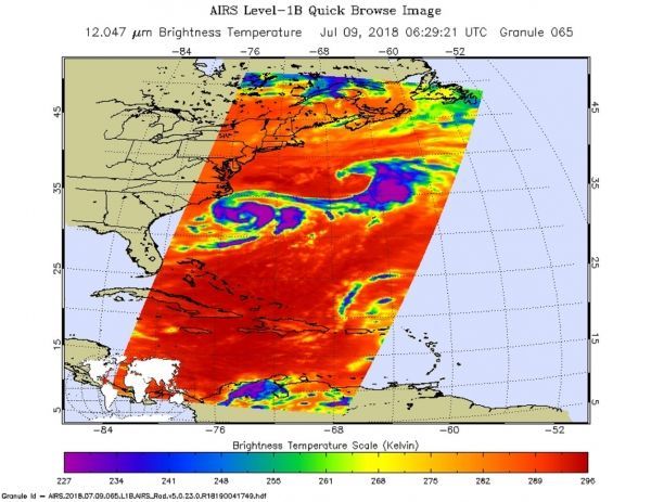
NASA's Aqua satellite passed over Chris on July 9 at 2:29 a.m. EDT (0629 UTC) and analyzed the storm in infrared light. Infrared light provides temperature data and that's important when trying to understand how strong storms can be. The higher the cloud tops, the colder and the stronger they are.
AIRS found coldest cloud top temperatures around the storm's center and in a thick band east of the center. Northeast of Chris was a frontal boundary that also contained very cold cloud top temperatures. Those temperatures were as cold as minus 63 degrees Fahrenheit (minus 53 degrees Celsius). Storms with cloud top temperatures that could have the capability to produce heavy rainfall.
Read more at NASA / Goddard Space Flight Center
Image: NASA's Aqua satellite passed over Tropical Storm Chris on July 9 at 2:29 a.m. EDT (0629 UTC) and saw coldest cloud top temperatures (purple) around the storm's center and in a thick band east of the center. CREDITS: NASA JPL / Heidar Thrastarson


