
Infrared imagery from NASA revealed two small area of strong storms remained in the remnants of Tropical Storm Beryl, moving into the eastern Caribbean Sea.
Infrared imagery from NASA revealed two small area of strong storms remained in the remnants of Tropical Storm Beryl, moving into the eastern Caribbean Sea.
Beryl lost its tropical storm status by 5 p.m. EDT on July 8. Beryl degenerated into a remnant low pressure area before it crossed over the Northern Leeward Islands late on July 8.
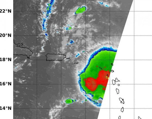
NASA's Aqua satellite passed over Tropical Storm Beryl on July 9 at 2:35 a.m. EDT (0635 UTC) and analyzed the storm in infrared light. The MODIS or Moderate Resolution Imaging Spectroradiometer instrument aboard NASA’s Aqua satellite revealed two small areas of strong thunderstorms where cloud top temperatures as cold or colder than minus 70 degrees Fahrenheit (minus 56.6 degrees Celsius). One area was in the eastern Caribbean Sea, the other over the Northern Leeward Islands. Cloud tops with temperatures that cold have the potential to generate very heavy rainfall.
Read more at NASA/Goddard Space Flight Center
Image: NASA's Aqua satellite passed over Tropical Storm Beryl on July 9 at 2:35 a.m. EDT (0635 UTC) and revealed two small area of strong thunderstorms (red) where cloud top temperatures as cold or colder than minus 70 degrees Fahrenheit (minus 56.6 degrees Celsius). One area was in the eastern Caribbean Sea, the other over the Northern Leeward Islands. (Credit: NASA/NRL)


