
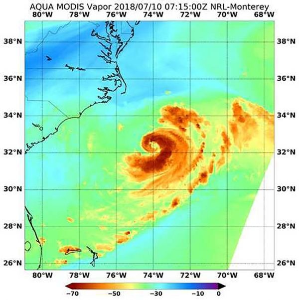
When NASA's Aqua satellite passed over the northwestern Atlantic Ocean, an instrument aboard looked at Tropical Storm Chris' water vapor and cloud temperatures. Appropriately, the image showed a backwards "C" or comma shaped storm. The water vapor imagery indicated Tropical Storm Chris has the potential to generate heavy rainfall.
When NASA's Aqua satellite passed over the northwestern Atlantic Ocean, an instrument aboard looked at Tropical Storm Chris' water vapor and cloud temperatures. Appropriately, the image showed a backwards "C" or comma shaped storm. The water vapor imagery indicated Tropical Storm Chris has the potential to generate heavy rainfall.
NASA's Aqua satellite passed over Chris on July 10 at 3:15 a.m. EDT (0715 UTC) and analyzed the water vapor content within the storm. Water vapor imagery is used to analyze the movement and presence of water vapor moisture in the middle and upper levels of the atmosphere. Those levels range from about 650 millibars to the top of the troposphere.
The MODIS or Moderate Resolution Imaging Spectroradiometer instrument aboard NASA’s Aqua satellite showed cloud top temperatures as cold or colder than minus 70 degrees Fahrenheit (minus 56.6 degrees Celsius). Cloud tops with temperatures that could have the potential to generate very heavy rainfall.
Read more at NASA / Goddard Space Flight Center
Image: NASA's Aqua satellite passed over Chris on July 10 at 3:15 a.m. EDT (0715 UTC) and analyzed the water vapor content within the storm. The MODIS instrument aboard NASA’s Aqua satellite showed cloud top temperatures as cold or colder than minus 70 degrees Fahrenheit (minus 56.6 degrees Celsius). CREDITS: NASA / NRL


