
As the remnants of former tropical cyclone Beryl moved through the northern Leeward Islands and Puerto Rico, the Global Precipitation Measurement mission or GPM core satellite gathered important rainfall data on the storm.
As the remnants of former tropical cyclone Beryl moved through the northern Leeward Islands and Puerto Rico, the Global Precipitation Measurement mission or GPM core satellite gathered important rainfall data on the storm.
NASA's GPM core observatory satellite recently had two excellent views of Hurricane Beryl's remnants. GPM flew above on July 8, 2018 at 7:26 p.m. EDT (2326 UTC) when Beryl's remnants were passing through the Windward Islands.
Harold Pierce of NASA's Goddard Space Flight Center in Greenbelt, Maryland, used GPM data to create images and animations of the rainfall and cloud heights in the storm. Pierce said, "Beryl's remnants still contained areas of strong convective storms as it passed near the island of Dominica. GPM's Microwave Imager (GMI) and Dual-Frequency Precipitation Radar (DPR) instruments showed that strong convective storms northeast of Dominica were dropping rain at a rate of greater than 75 mm (2.95 inches) per hour. "
Dominica is still recovering from Hurricane Maria which devastated the island last year. Most of the homes on Dominica were damaged or destroyed.
Read more at NASA/Goddard Space Flight Center
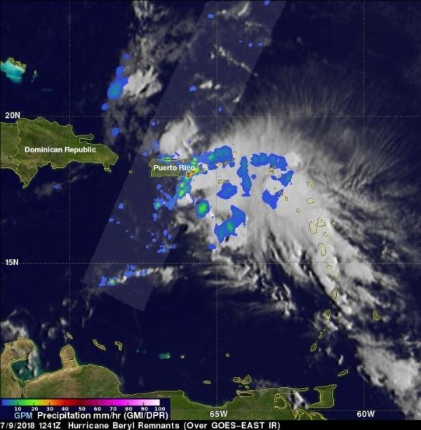
Image: The GPM core satellite passed above the remnants of Beryl again on July 9, 2018 at 8:41 a.m. EDT (1241 UTC) as bands of rain were moving over Puerto Rico. Very heavy rain was occurring in a small area along Puerto Rico's southeastern coast. Intense storms there were measured by GPM's radar dropping rain at a rate of over 81 mm (3.2 inches) per hour. (Credit: NASA/JAXA, Hal Pierce)


