
As Tropical Storm Chris was strengthening into a short-lived hurricane, the Global Precipitation Measurement mission or GPM core satellite investigated the storm's rainfall and cloud heights. By July 12, Chris weakened to a tropical storm and was passing by Nova Scotia, Canada.
As Tropical Storm Chris was strengthening into a short-lived hurricane, the Global Precipitation Measurement mission or GPM core satellite investigated the storm's rainfall and cloud heights. By July 12, Chris weakened to a tropical storm and was passing by Nova Scotia, Canada.
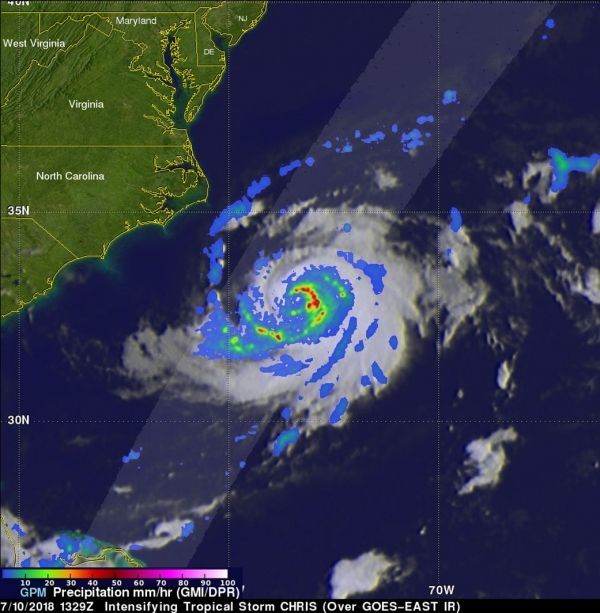
On July 11, Chris became a category two hurricane on the Saffir-Simpson hurricane wind scale. The GPM core observatory satellite flew above Chris on July 10, 2018 at 9:29 a.m. EDT (1329 UTC) when Chris was becoming a hurricane. Chris' movement toward the northeast over warmer waters east of the Atlantic coast were assisting in the tropical cyclone's intensification. GPM's Microwave Imager (GMI) and
Dual-Frequency Precipitation Radar (DPR) instruments revealed that intense bands of precipitation were wrapping around the eastern side of the intensifying tropical storm. GPM's radar (DPR Ku Band) indicated that rain was falling at over 123 mm (4.8 inches) per hour in strong convective storms east of CHRIS' forming eye.
Read more at NASA / Goddard Space Flight Center
Image: GPM flew above Chris on July 10, 2018 at 9:29 a.m. EDT (1329 UTC). GPM's radar (DPR Ku Band) indicated that rain was falling at over 123 mm (4.8 inches) per hour in strong convective storms east of CHRIS' forming eye. GPM found some storm tops in the forming eye wall were reaching heights above 13 km (8.1 miles). CREDITS: NASA / JAXA, Hal Pierce


