
While passing over the Central Pacific Ocean, NASA's Terra satellite stared Hurricane Lane in the eye. Hurricane Lane continued to show a large eye surrounded by powerful storms. An infrared look by NASA's Terra satellite provided temperatures of those storms, confirming strong, high thunderstorms capable of very heavy rainfall.
While passing over the Central Pacific Ocean, NASA's Terra satellite stared Hurricane Lane in the eye. Hurricane Lane continued to show a large eye surrounded by powerful storms. An infrared look by NASA's Terra satellite provided temperatures of those storms, confirming strong, high thunderstorms capable of very heavy rainfall.
NOAA's Central Pacific Hurricane Center or CPHC cautioned on Tuesday, August 21, 2018, "Major Hurricane Lane expected to make a turn toward the Hawaiian Islands later this week." Interests in the main Hawaiian Islands and across the Northwestern Hawaiian Islands should continue to closely monitor the progress of Hurricane Lane. A Hurricane Watch may be required for portions of the main Hawaiian Islands on Tuesday.
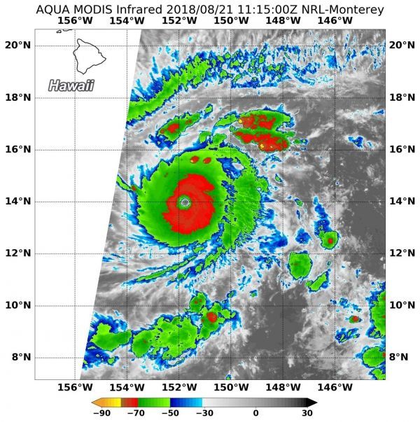
On Aug. 21 at 7:15 a.m. EDT (1115 UTC) the Moderate Resolution Imaging Spectroradiometer or MODIS instrument aboard NASA's Terra satellite analyzed Lane's cloud top temperatures in infrared light. MODIS found cloud top temperatures of strongest thunderstorms in the eyewall were as cold as or colder than minus 80 degrees Fahrenheit (minus 62.2 Celsius). They were surrounded by a larger area of storms with cloud tops as cold as minus 70 degrees Fahrenheit (minus 56.6 degrees Celsius). Cloud top temperatures that could indicate strong storms that have the capability to create heavy rain.
Read more at NASA / Goddard Space Flight Center
Image: On Aug. 21 at 7:15 a.m. EDT (1115 UTC) NASA's Terra satellite found coldest temperatures of strongest thunderstorms (yellow) in Hurricane Lane were as cold as or colder than minus 80 degrees Fahrenheit (minus 62.2 Celsius) in the eyewall. They were surrounded by a larger area of storms with cloud tops as cold as minus 70 degrees (red) Fahrenheit (minus 56.6 degrees Celsius). CREDITS: NRL / NASA


