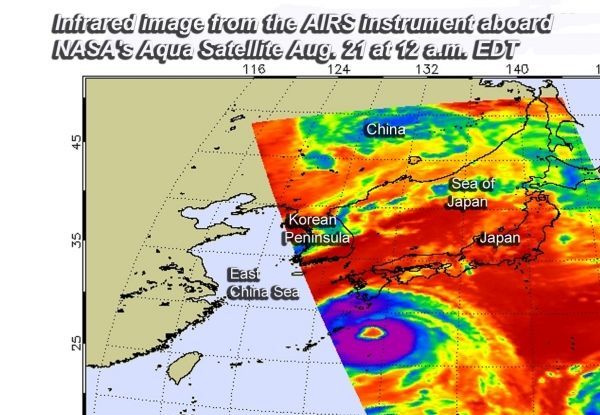
NASA's Aqua satellite provided forecasters with a look at Typhoon Soulik's cloud top temperatures and 50 nautical-mile wide eye as it passed overhead on Aug. 21.
NASA's Aqua satellite provided forecasters with a look at Typhoon Soulik's cloud top temperatures and 50 nautical-mile wide eye as it passed overhead on Aug. 21.
The Atmospheric Infrared Sounder or AIRS instrument observed Typhoon Soulik in infrared light which measures cloud top temperatures. The colder the cloud top, the higher it extends in the troposphere. High cloud tops indicate powerful uplift of air in the storm.
Enhanced infrared satellite imagery showed very strong thunderstorms as cold as or colder than minus 63 degrees Fahrenheit (minus 53 Celsius) surrounding Typhoon Soulik's 50-mile-wide eye. Imagery also showed spiral banding of thunderstorms wrapping around the eye with a partially eroded eye wall in the western side. A microwave image depicts a symmetric system with a well-defined microwave eye feature, which supports the initial position with good confidence.
Read more at NASA / Goddard Space Flight Center
Image: On Aug. 21 at 12:00 a.m. EDT (0400 UTC) the AIRS instrument aboard NASA's Aqua satellite showed very strong thunderstorms (purple) as cold as or colder than minus 63 degrees Fahrenheit (minus 53 Celsius) surrounding Typhoon Soulik's 50-mile-wide eye. CREDITS: NASA JPL, Heidar Thrastarson


