
NASA satellites are providing a lot of different kinds of data to forecasters at the National Hurricane Center to help them understand what’s happening Hurricane Florence. NASA’s Aqua satellite is providing visible, infrared and microwave imagery while the GPM core satellite is providing additional data like rain rates throughout the storm and cloud heights.
NASA satellites are providing a lot of different kinds of data to forecasters at the National Hurricane Center to help them understand what’s happening Hurricane Florence. NASA’s Aqua satellite is providing visible, infrared and microwave imagery while the GPM core satellite is providing additional data like rain rates throughout the storm and cloud heights.
Last Friday, Sept. 7, Florence was a sheared tropical storm but on Saturday vertical shear lessened and Florence started to get better organized. Today, Sept. 10 Hurricane Florence was rapidly strengthening and became a major hurricane.
NOAA’s National Hurricane Center (NHC) said “Interests in the southeastern and mid-Atlantic states should monitor the progress of Florence. Storm Surge and Hurricane watches could be issued for portions of these areas by Tuesday morning”.
The Global Precipitation Measurement mission or GPM core observatory satellite had a fairly good look at Florence on Sunday, Sept. 9, 2018 at 2:13 p.m. EDT (1813 UTC). GPM is a joint satellite mission between NASA and the Japan Aerospace Exploration Agency called JAXA.
Read more at NASA/Goddard Space Flight Center
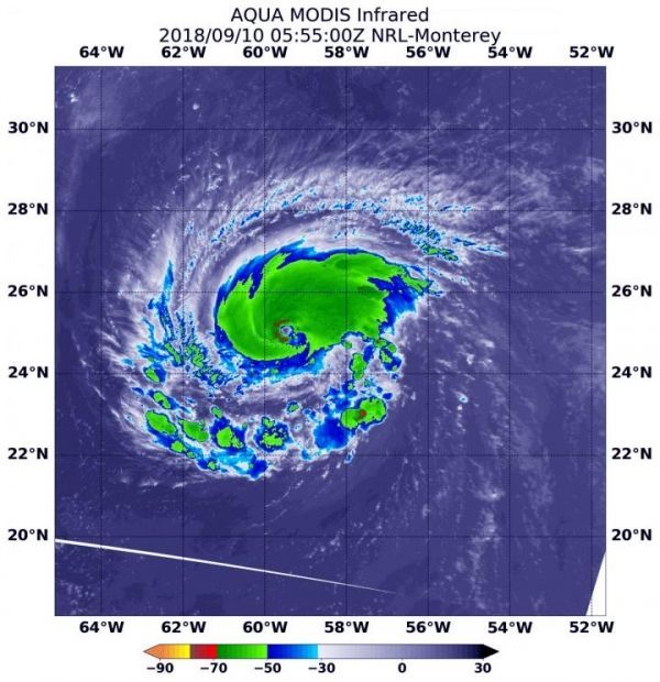
Image: At 1:55 a.m. EDT (0555 UTC) on Sept. 10, the MODIS instrument aboard NASA's Aqua satellite looked at Hurricane Florence in infrared light. MODIS found coldest cloud tops (red) had temperatures near minus 70 degrees Fahrenheit (minus 56.6 degrees Celsius) in the northern and western eyewall. (Credit: NASA/NRL)


