
Hurricane Olivia moved from the Eastern Pacific into the Central Pacific and is expected to affect Hawaii. NASA’s Aqua satellite the northeast and southwestern quadrants of the storm to be the most powerful on Sept. 10.
Hurricane Olivia moved from the Eastern Pacific into the Central Pacific and is expected to affect Hawaii. NASA’s Aqua satellite the northeast and southwestern quadrants of the storm to be the most powerful on Sept. 10.
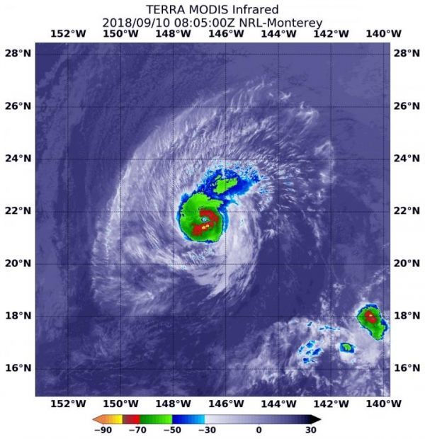
Infrared satellite data at 12:15 a.m. EDT (0415 UTC) on Sept. 10 from the Moderate Resolution Imaging Spectroradiometer or MODIS instrument aboard NASA’s Aqua satellite revealed the strongest storms were southwest and northeast of the center. In those areas MODIS found coldest cloud tops had temperatures near minus 70 degrees Fahrenheit (minus 56.6 degrees Celsius). NASA research has found that cloud top temperatures that cold have the capability to generate heavy rainfall.
The MODIS data showed that the strongest storms only extended out 30 miles from the center. Hurricane-force winds extend outward up to 30 miles (45 km) from the center and tropical-storm-force winds extend outward up to 115 miles (185 km).
Read more at NASA/Goddard Space Flight Center
Image: At 12:15 a.m. EDT (0415 UTC) on Sept. 10, the MODIS instrument aboard NASA's Aqua satellite looked at Hurricane Olivia in infrared light. MODIS found coldest cloud tops (red) had temperatures near minus 70 degrees Fahrenheit (minus 56.6 degrees Celsius) around the center. (Credit: NASA/NRL)


