
NASA’s Aqua satellite provided an infrared look at Helene as it continued tracking toward the Azores Islands in the Eastern Atlantic Ocean. Satellite imagery shows that Helene is decoupled from wind shear.
NASA’s Aqua satellite provided an infrared look at Helene as it continued tracking toward the Azores Islands in the Eastern Atlantic Ocean. Satellite imagery shows that Helene is decoupled from wind shear.
The National Hurricane Center or NHC said “Helene’s surface circulation has become fully exposed this morning with the center decoupled about 110 miles south of edge of the remaining deep convection.” That means that the circulation or center of the storm is off-center, and the bulk of the storm has been pushed away from the rotating center. That decoupling happened because Helene is dealing with southwesterly (coming from the southwest) vertical wind shear. NHC noted that the wind shear is expected to increase later on Sept. 13.
What is Wind Shear?
In general, wind shear is a measure of how the speed and direction of winds change with altitude. Wind shear can tear a tropical cyclone apart or weaken it.
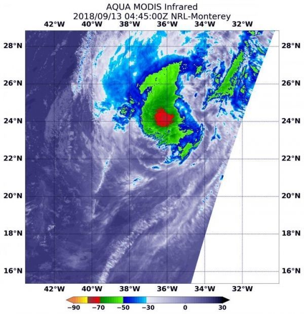
NASA’s Infrared View of Helene
NASA’s Aqua satellite passed over Hurricane Helene on Sept. 13 at 12:45 a.m. EDT (0445 UTC) and the Moderate Resolution Imaging Spectroradiometer or MODIS instrument aboard analyzed cloud top temperatures in infrared light. Coldest cloud top temperatures were being pushed northeast of center and were as cold as or colder than minus 70 degrees Fahrenheit (minus 56.6 Celsius). Cloud top temperatures that cold indicate strong storms that have the capability to create heavy rain.
Read more at NASA/Goddard Space Flight Center
Image: NASA's Aqua satellite passed over Hurricane Helene on Sept. 13 at 12:45 a.m. EDT (0445 UTC) and analyzed it in infrared light. Strongest storms with coldest cloud tops appeared in red. (Credit: NASA/NRL)


