
NASA’s Aqua satellite provided an infrared look at the large and powerful Hurricane Florence early on Sept. 13 that indicated wind shear was temporarily affecting the southern side of the storm.
NASA’s Aqua satellite provided an infrared look at the large and powerful Hurricane Florence early on Sept. 13 that indicated wind shear was temporarily affecting the southern side of the storm.
The National Hurricane Center or NHC noted that hurricane-force winds extend outward up to 80 miles (130 km) from the center and tropical-storm-force winds extend outward up to 195 miles (315 km).
Infrared and Microwave Satellite Images Reveal
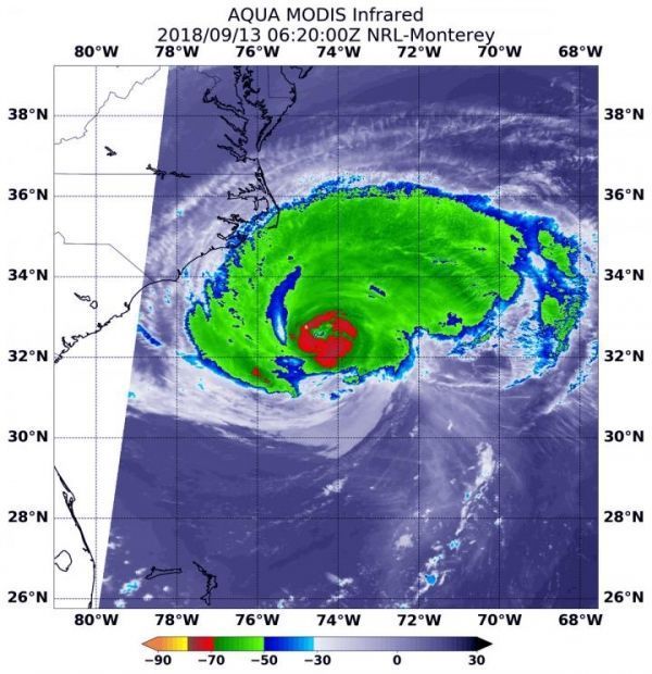
Early on Sept. 13, NASA’s Aqua satellite’s infrared data showed the clouds in the southern quadrant of Hurricane Florence appeared warmer than storms throughout the rest of Florence. That means that the cloud tops are lower in the atmosphere, and the storms are not as powerful. That’s because vertical wind shear, the change of speed and direction of winds with altitude was buffeting the southern side of Florence and preventing the development of higher, stronger thunderstorms in that part of the storm.
NOAA’s National Hurricane Center (NHC) said “microwave overpass indicated that the convection over the southern and southeastern portions of the storm is still disrupted, and that the eyewall was open to the southeast. It appears that some southern shear has caused the degradation of the inner core. The global models suggest that this shear will relax today while Florence moves over warm waters, however, given the current storm structure, little overall change in strength is anticipated as Florence approaches the coast.”
Read more at NASA/Goddard Space Flight Center
Image: At 2:20 a.m. EDT (0620 UTC) on Sept. 13, 2018 the MODIS instrument aboard NASA's Aqua satellite looked at Hurricane Florence in infrared light. MODIS found a small ring of coldest cloud top temperatures around the eye, as cold as or colder than minus 80 degrees (yellow) Fahrenheit (minus 112 degrees Celsius). Surrounding the eye were thick rings of powerful storms with cloud tops as cold as or colder than minus 70 degrees (red) Fahrenheit (minus 56.6 degrees Celsius). (Credit: NASA/NRL)


