
NASA’s Aqua satellite provided an infrared look at Tropical Depression Joyce and found wind shear was pushing the bulk of clouds and showers to the east of the center.
NASA’s Aqua satellite provided an infrared look at Tropical Depression Joyce and found wind shear was pushing the bulk of clouds and showers to the east of the center.
The National Hurricane Center noted at 5 a.m. EDT on Sept. 18, “The latest convective burst associated with Joyce is weakening due to the effects of 35 to 40 knots of westerly vertical [wind] shear and very dry mid-level air.”
In general, wind shear is a measure of how the speed and direction of winds change with altitude. Wind shear can tear a tropical cyclone apart or weaken it.
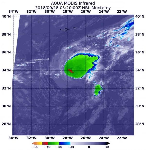
At 11:20 p.m. EDT on Sept. 17 (0320 UTC on Sept. 18), Moderate Resolution Imaging Spectroradiometer or MODIS instrument aboard NASA’s Aqua satellite analyzed Tropical Depression Joyce in infrared light. MODIS found a small area of coldest cloud top temperatures around the center of circulation. Those were as cold as or colder than minus 70 degrees Fahrenheit (minus 56.6 degrees Celsius). The bulk of the storm, however, was being pushed to the northeast from the wind shear.
Read more at NASA/Goddard Space Flight Center
Image: At 11:20 p.m. EDT on Sept. 17 (0320 UTC on Sept. 18), the MODIS instrument aboard NASA's Aqua satellite looked at Tropical Depression Joyce in infrared light. MODIS found a small area of coldest cloud top temperatures around the center of circulation. Those were as cold as or colder than minus 70 degrees (red) Fahrenheit (minus 56.6 degrees Celsius). Joyce is located south of the Azores Islands. (Credit: NASA/NRL)


