
NASA’s Aqua satellite provided an infrared look at fading Post-Tropical Cyclone Florence’s clouds, revealing where the strongest thunderstorms were located. Those strong thunderstorms stretched from the Mid-Atlantic to New England.
NASA’s Aqua satellite provided an infrared look at fading Post-Tropical Cyclone Florence’s clouds, revealing where the strongest thunderstorms were located. Those strong thunderstorms stretched from the Mid-Atlantic to New England.
On Sept. 18, Florence is becoming an increasingly elongated low pressure area while it generates heavy rain over parts of the Mid-Atlantic and into southern New England today. Flash flood watches are in effect for portions of the Mid-Atlantic States and southern New England.
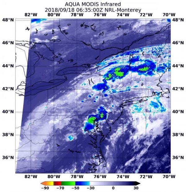
At 2:35 a.m. EDT (0635) on Sept. 18, the Moderate Resolution Imaging Spectroradiometer or MODIS instrument aboard NASA’s Aqua satellite analyzed Post-Tropical Cyclone Florence in infrared light. MODIS found several areas of coldest cloud top temperatures and strongest storms located over several U.S. states: Maryland, Delaware, northeastern upstate New York, central Vermont and New Hampshire.
Read more at NASA/Goddard Space Flight Center
Image: At 2:35 a.m. EDT (0635) on Sept. 18, 2018, NASA's Aqua satellite analyzed Post-Tropical Cyclone Florence in infrared light and found several areas of coldest cloud top temperatures and strongest storms (yellow) located over several U.S. states: Maryland, Delaware, northeastern upstate New York, central Vermont and New Hampshire. Those cloud top temperatures were as cold as or colder than minus 63 degrees Fahrenheit (minus 53 degrees Celsius). (Credit: NASA/NRL)


